skip to main |
skip to sidebar
 I discovered a copy of Arthur J Brown’s 1931 walkers guide to the “West Yorkshire” moors in the banqueting hall at Knipe Towers, “Moorland Tramping.” By “West Yorkshire”, by the way, this chap means, of course, the West Riding of Yorkshire – the county which once stretched from Doncaster to The Calf, and includes a great lump of the Forest of Bowland, too. So, there’s plenty of moors.
Mr Brown says that as the roads are getting very busy and quite dangerous due to the spread of the motor car, that walkers, or “trampers” are going to have to find somewhere a bit safer to walk – and he’s come up with the suggestion that the moors hold lots of tracks that go from one place to another and which make ideal routes away from all that nasty traffic. Hmmmm…. I think he’s got something here….
I discovered a copy of Arthur J Brown’s 1931 walkers guide to the “West Yorkshire” moors in the banqueting hall at Knipe Towers, “Moorland Tramping.” By “West Yorkshire”, by the way, this chap means, of course, the West Riding of Yorkshire – the county which once stretched from Doncaster to The Calf, and includes a great lump of the Forest of Bowland, too. So, there’s plenty of moors.
Mr Brown says that as the roads are getting very busy and quite dangerous due to the spread of the motor car, that walkers, or “trampers” are going to have to find somewhere a bit safer to walk – and he’s come up with the suggestion that the moors hold lots of tracks that go from one place to another and which make ideal routes away from all that nasty traffic. Hmmmm…. I think he’s got something here….
 And so, after going on about equipment for a bit, in which he decries the use of boots as being too heavy, he suggests saving up and paying a cobbler the princely sum of £3 to have some proper shoes made. He also suggests supervising the cobbler whilst he spends long candle-lit nights in his cobbling shop cobbling your shoes. These shoes can be expected to last for years and years although they may have to be bailed out occasionally. If its snowing or raining very heavily, then some chunky boots may be allowed.
On rucksacks, he recommends the lightest available. Inside the pack should be a roast beef sandwich and an apple and a waterproof cape. Other essential things such as your guidebook, map, compass, volume of poetry, pipe, tobacco, matches and railway tickets, can be stored in the pockets of your tweed jacket. He does, however, have some reservations about maps and compasses because people who use them are “forever stopping en route to consult their instruments”, although he does concede that a person of a scientific mind may well derive some enjoyment from studying maps and, perhaps, taking an observation every hour or so…. (all good clean fun this, eh?)
On “ultra lightweight”, Mr Brown suggests staying in a pub overnight. Your accommodation should be your very last economy. Far too much lumber is carried by the youth of today.
You should also consider using a stout staff or pole. This should be a straight piece of ash. This can be used to persuade cattle or to test the depth of snowdrifts.
And so, after going on about equipment for a bit, in which he decries the use of boots as being too heavy, he suggests saving up and paying a cobbler the princely sum of £3 to have some proper shoes made. He also suggests supervising the cobbler whilst he spends long candle-lit nights in his cobbling shop cobbling your shoes. These shoes can be expected to last for years and years although they may have to be bailed out occasionally. If its snowing or raining very heavily, then some chunky boots may be allowed.
On rucksacks, he recommends the lightest available. Inside the pack should be a roast beef sandwich and an apple and a waterproof cape. Other essential things such as your guidebook, map, compass, volume of poetry, pipe, tobacco, matches and railway tickets, can be stored in the pockets of your tweed jacket. He does, however, have some reservations about maps and compasses because people who use them are “forever stopping en route to consult their instruments”, although he does concede that a person of a scientific mind may well derive some enjoyment from studying maps and, perhaps, taking an observation every hour or so…. (all good clean fun this, eh?)
On “ultra lightweight”, Mr Brown suggests staying in a pub overnight. Your accommodation should be your very last economy. Far too much lumber is carried by the youth of today.
You should also consider using a stout staff or pole. This should be a straight piece of ash. This can be used to persuade cattle or to test the depth of snowdrifts.
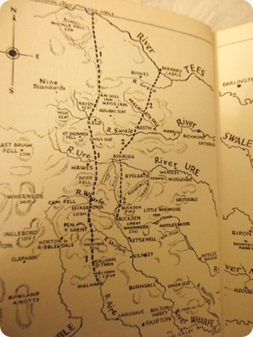
 Mr Brown then goes on to describe some routes, and in doing this, I am immediately reminded of Alf Wainwright and his Pennine Journey, for one of the first routes to appear is a “Yorkshire Rivers” walk from Malham (Aire) to High Force (Tees) The south bank of the river Tees is firmly in Yorkshire, as every true Yorkshireman will attest. This route can then be extended to Hadrian’s Wall if a longer holiday is required. Justaminnit….. this was 1931 – just half a decade before Alf had the same idea…. I wonder if Alf had a copy of “Moorland Tramping”? Was it, I wonder, available in the public library in Blackburn?
No matter.
The there’s the “Three Peaks in One Day” route. Hello?
Two routes are suggested.
The first starts at the Hill Inn at Chapel le Dale and the tramper is recommended to climb Whernside first, returning to the Inn for breakfast. A walk over Ingleborough to the Crown at Horton in Ribblesdale follows where light refreshments may be taken before bagging Penyghent and returning to Horton for more refreshments and the train home.
Route two starts at the Sun Inn in Dent at 07:00
then the following timetable applies:
Whernside Pikes 08:10
Whernside 09:00 to 09:30
Hill in Chapel le Dale 10:30 to 10:45
Ingleborough 12:00 to 12:15
Crown Inn Horton in Riblesdale 14:00 to 15:00 (lunch)
Hull Pot 15:45
Penyghent 16:50
Hesleden Gill Bridge 17:15
Litton 18:15 to 18:45
Kilnsey 21:15
Presumably a night at the hotel at Kilnsey follows.
This is quite a timetable.
Anyway, the point is that I’m Inspired to have a go at these routes – Malham to High Force in a pretty straight line – and the Three Peaks from Dent to Wharfedale (probably go to Grassington) – though, one day may seem like a punishment, but Dent – Horton and Horton – Grassington may be more like fun – that is to say, two days.
So, this year, at some point, I’ll be doing some Moorland Tramping.
Mr Brown then goes on to describe some routes, and in doing this, I am immediately reminded of Alf Wainwright and his Pennine Journey, for one of the first routes to appear is a “Yorkshire Rivers” walk from Malham (Aire) to High Force (Tees) The south bank of the river Tees is firmly in Yorkshire, as every true Yorkshireman will attest. This route can then be extended to Hadrian’s Wall if a longer holiday is required. Justaminnit….. this was 1931 – just half a decade before Alf had the same idea…. I wonder if Alf had a copy of “Moorland Tramping”? Was it, I wonder, available in the public library in Blackburn?
No matter.
The there’s the “Three Peaks in One Day” route. Hello?
Two routes are suggested.
The first starts at the Hill Inn at Chapel le Dale and the tramper is recommended to climb Whernside first, returning to the Inn for breakfast. A walk over Ingleborough to the Crown at Horton in Ribblesdale follows where light refreshments may be taken before bagging Penyghent and returning to Horton for more refreshments and the train home.
Route two starts at the Sun Inn in Dent at 07:00
then the following timetable applies:
Whernside Pikes 08:10
Whernside 09:00 to 09:30
Hill in Chapel le Dale 10:30 to 10:45
Ingleborough 12:00 to 12:15
Crown Inn Horton in Riblesdale 14:00 to 15:00 (lunch)
Hull Pot 15:45
Penyghent 16:50
Hesleden Gill Bridge 17:15
Litton 18:15 to 18:45
Kilnsey 21:15
Presumably a night at the hotel at Kilnsey follows.
This is quite a timetable.
Anyway, the point is that I’m Inspired to have a go at these routes – Malham to High Force in a pretty straight line – and the Three Peaks from Dent to Wharfedale (probably go to Grassington) – though, one day may seem like a punishment, but Dent – Horton and Horton – Grassington may be more like fun – that is to say, two days.
So, this year, at some point, I’ll be doing some Moorland Tramping.
 The heat of the sun got me out of bed and I was away by 9:00 ish (ok, I know its not early, but if you’d been to Darts practise at the Hare and Hounds….) I called at Charlie’s and had coffee….
A bit later I slugged up the hill out of Westgate. various people stopped to chat. It took a while.
Eventually, at a strategic bend in the road, I headed off along a contour with a lane on it and this took me towards Heights Quarry. it was all very lovely so far.
The heat of the sun got me out of bed and I was away by 9:00 ish (ok, I know its not early, but if you’d been to Darts practise at the Hare and Hounds….) I called at Charlie’s and had coffee….
A bit later I slugged up the hill out of Westgate. various people stopped to chat. It took a while.
Eventually, at a strategic bend in the road, I headed off along a contour with a lane on it and this took me towards Heights Quarry. it was all very lovely so far.
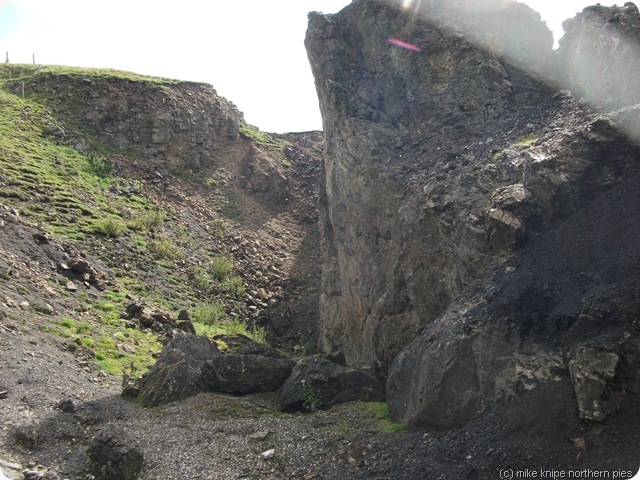 The route follows the old railway line to Rookhope and its all very lovely with some smashing Weardale views until a deep gorge suddenly appears at the feet. There is a moment of doubt (cos its a big drop) – but by poking around, a path on the left is found which drops down gently to the beck and then appears on the other side of the gorge without much at all in the way of drama. For geologists, there’s a very nice mined-out mineral vein here.
For about a kilometre after this point, its best to keep your left eye closed. The path goes alongside heights Quarry, which is still working and is very busy. Its well waymarked and fenced off from any danger and eventually industry is passed and the intrepid Pennine Journier pops out on the other side into old railway cuttings with bits of woodland, lots of flowers and many buzzing insects. Its green and damp and beautiful.
The route follows the old railway line to Rookhope and its all very lovely with some smashing Weardale views until a deep gorge suddenly appears at the feet. There is a moment of doubt (cos its a big drop) – but by poking around, a path on the left is found which drops down gently to the beck and then appears on the other side of the gorge without much at all in the way of drama. For geologists, there’s a very nice mined-out mineral vein here.
For about a kilometre after this point, its best to keep your left eye closed. The path goes alongside heights Quarry, which is still working and is very busy. Its well waymarked and fenced off from any danger and eventually industry is passed and the intrepid Pennine Journier pops out on the other side into old railway cuttings with bits of woodland, lots of flowers and many buzzing insects. Its green and damp and beautiful.
 After that, the Weardale Way goes easily along the railway line to Rookhope where it meets the cyclists’ Coast to Coast route and, of course, the Rookhope Inn where a short period of celebration is allowed.
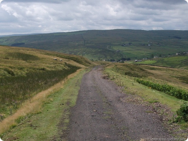 After “lunch”, I climbed the Bolts law incline, a bit wearily and followed PJ instructions to go and bag Bolts Law, scene of recent solstice partying. There’s a lot of grouse living in the Bolts Law heather, and its very heavily managed, so if I had a worry about the PJ route, it would be here. I’m not sure the shooting estate will be too chuffed about this route going through here. There could well be conflict. True, its open access, but its not open all the time, and Journiers with doggies will have to find another route.
 There is, in fact, a perfectly good footpath system from Rookhope running up by Stogel Clough and then over the North East slope of Bolts Law, crossing the summit and then down to Ramshaw. The path down to Ramshaw, though, is a mess. its difficult to follow, has what appears top be an old leat which is crossed on a rotten footbridge, and there’s electric fences. And lots of thistles. But its a right of way and can’t be closed. It just needs a bit of TLC, really. I followed this path down to Ramshaw, as best I could. I might report this to Durham County Council. I’m not sure its bad enough, though.
 After Ramshaw, there’s some quiet lanes and some woodland footpaths to Baybridge, then a pleasant riverside path to Blanchland.
There’s no phone signal in Blanchland, so I used the phonebox to ring home. I got a minute for 60p. 60 PENCE for a minute. Absolute robbery. I allowed myself to be exploited to the sum of three pints of Black Sheep in the Lord Crewe Arms whilst waiting for Maggie to arrive.
After Ramshaw, there’s some quiet lanes and some woodland footpaths to Baybridge, then a pleasant riverside path to Blanchland.
There’s no phone signal in Blanchland, so I used the phonebox to ring home. I got a minute for 60p. 60 PENCE for a minute. Absolute robbery. I allowed myself to be exploited to the sum of three pints of Black Sheep in the Lord Crewe Arms whilst waiting for Maggie to arrive.
 And that, folks, is the sum of my Pennine Journey sampler.
It might not be exactly the route in the book. It won’t be far out though. Its not an official route anyway…
Today’s was 11 miles and 1300 feet.
And that, folks, is the sum of my Pennine Journey sampler.
It might not be exactly the route in the book. It won’t be far out though. Its not an official route anyway…
Today’s was 11 miles and 1300 feet.
 Y’see, I just couldn’t resist it. I got Maggie to drop me off in Middleton in Teesdale and I wandered up the Pennine Way up past Low Force and High Force and as far as Hanging Shaw, just by Forest in Teesdale First School just as playtime ended.
The Pennine Way here is specially flowery at the moment. And the haymeadows are just starting to be cut, so if you go there after reading this, there won’t be much left in the meadows, but the hedgerows and bits of woodland are really good.
Y’see, I just couldn’t resist it. I got Maggie to drop me off in Middleton in Teesdale and I wandered up the Pennine Way up past Low Force and High Force and as far as Hanging Shaw, just by Forest in Teesdale First School just as playtime ended.
The Pennine Way here is specially flowery at the moment. And the haymeadows are just starting to be cut, so if you go there after reading this, there won’t be much left in the meadows, but the hedgerows and bits of woodland are really good.

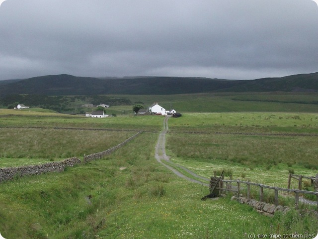 I walked along with a Dutch chap for a while and we parted just after Cronkley Farm.
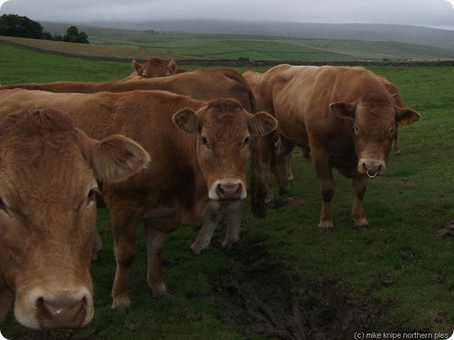
I haven’t yet ordered the official guidebook, so the next part of my route was a bit of a guess. the idea is to get onto the path that runs over the flank of Fendrith Hill to the top of the pass at Swinhope Head. I avoided a couple of fields containing energetic beef and made my way through meadows to Ettersgill where it started raining and I joined the path.
I walked along with a Dutch chap for a while and we parted just after Cronkley Farm.
I haven’t yet ordered the official guidebook, so the next part of my route was a bit of a guess. the idea is to get onto the path that runs over the flank of Fendrith Hill to the top of the pass at Swinhope Head. I avoided a couple of fields containing energetic beef and made my way through meadows to Ettersgill where it started raining and I joined the path.
 The route over to Swinhope Head is might well be tricky in hill fog (which was starting to drop as I made my way) and I used my compass to get the right directions.

 The first landmark is a “shooting hut”, which turns out to be just a ruin, but is easily found just below the 550 metre contour. A path leads off uphill but this turns out eventually to go too far uphill but a gently descending route across the moor brings the low profile of Grey Folds into view. I thought it was a good idea to go there. But first, there’s the small matter of the crossing of Longmere Sike, a deep shaley slot which was a bit slippery…. But anyway, after ejecting the sheep sheltering in the fold, so I could scoff a choccy bar in peace, more hillfog and misty grey stuff brought a power line into view and it was then a simple matter of following these as they go very close to the cattle grid at the top of the pass. It was a bit of a relief to get on the road here.
My advice for anybody struggling with the navigation here is to fight your way North-east to the road. Another option would be to follow the power line uphill, though you’d eventually get so close to the road that it’d be too tempting…..
The first landmark is a “shooting hut”, which turns out to be just a ruin, but is easily found just below the 550 metre contour. A path leads off uphill but this turns out eventually to go too far uphill but a gently descending route across the moor brings the low profile of Grey Folds into view. I thought it was a good idea to go there. But first, there’s the small matter of the crossing of Longmere Sike, a deep shaley slot which was a bit slippery…. But anyway, after ejecting the sheep sheltering in the fold, so I could scoff a choccy bar in peace, more hillfog and misty grey stuff brought a power line into view and it was then a simple matter of following these as they go very close to the cattle grid at the top of the pass. It was a bit of a relief to get on the road here.
My advice for anybody struggling with the navigation here is to fight your way North-east to the road. Another option would be to follow the power line uphill, though you’d eventually get so close to the road that it’d be too tempting…..
 The rest of the walk to Westgate follows this road, although there’s a shortcut through deep and damp Juncus (rushes) to Weardale Ski Club’s parking area which cuts out the zig-zags. It gets a bit dull after that, although forward views into Weardale improve with the descent.
I camped on the little campsite by the ford.
The rest of the walk to Westgate follows this road, although there’s a shortcut through deep and damp Juncus (rushes) to Weardale Ski Club’s parking area which cuts out the zig-zags. It gets a bit dull after that, although forward views into Weardale improve with the descent.
I camped on the little campsite by the ford.
 A neo-air takes 28 manly puffs to inflate it properly. I was just inserting manly puff number eight when I heard my name called. I peeked out and there was Charlie, inviting me for tea. We had lamb chops (very nice, Charlie) and then visited the Hare and Hounds for the darts team practise night. I got back to the tent fairly late…….. It had stopped raining.
Its about 15 miles and 2000 feet.
A neo-air takes 28 manly puffs to inflate it properly. I was just inserting manly puff number eight when I heard my name called. I peeked out and there was Charlie, inviting me for tea. We had lamb chops (very nice, Charlie) and then visited the Hare and Hounds for the darts team practise night. I got back to the tent fairly late…….. It had stopped raining.
Its about 15 miles and 2000 feet.
More of this shortly…


.jpg)


.jpg)


