statcounter

Saturday, 2 July 2016

Reccies for Guided Walks

mallerstang reccy 007

Before you embark (not “you” personally, what I really mean is “one”, but “one” always sounds so…er….well, too far up the wotsit…) before one embarks on leading any number of peeps on a guided walk, it is incumbent or necessary, obligatory, required and, generally thesauriously to do a reccy. Or even, maybe two reccies if the first one turns up stuff which might be hazardous or even just a bit dull.

mallerstang reccy 003

Over the next week or so, I am leading several guided walks, some for Durham County Council and some for the Wednesday Walkers Walking on Wednesdays and Often On Saturdays As Well – a kind of splinter group for the Durham CC customers if the Durham CC programme doesn’t provide walks with a reasonable amount of mileage on Wednesdays or Saturdays. And I went to do the reccie.

mallerstang reccy 005

Two such walks are next week: A nine-miler starting at Blanchland and a linear walk from Garsdale Head train station to Kirkby Stephen train station, planned as a traverse of Mallerstang Edge but with at least two lower-level options in case of serious rain, and one option in case the train doesn’t turn up.

mallerstang reccy 009

I did the Mallerstang reccy a few days ago, along with LTD who thought the whole thing a jolly jape specially after he’d collared a dozy rabbit and made it squeak (I did rescue the rabbit fromn LTD’s substantially strong jaws and huge Staffy choppers)

mallerstang reccy 014

It was a good job I did, too since I discovered that one section of path had deteriorated significantly since the last time I was there with Bruno The Superdawg and was now rougher than a badger’s bottom parts and wetter and squishier than is absolutely necessary for full enjoyment of the steep contours involved. I’m not sure what happened to this pasture, except to say that there were now no sheep and but a few snoozing cattle – clearly not enough to keep down the rank vegetation.

mallerstang reccy 017

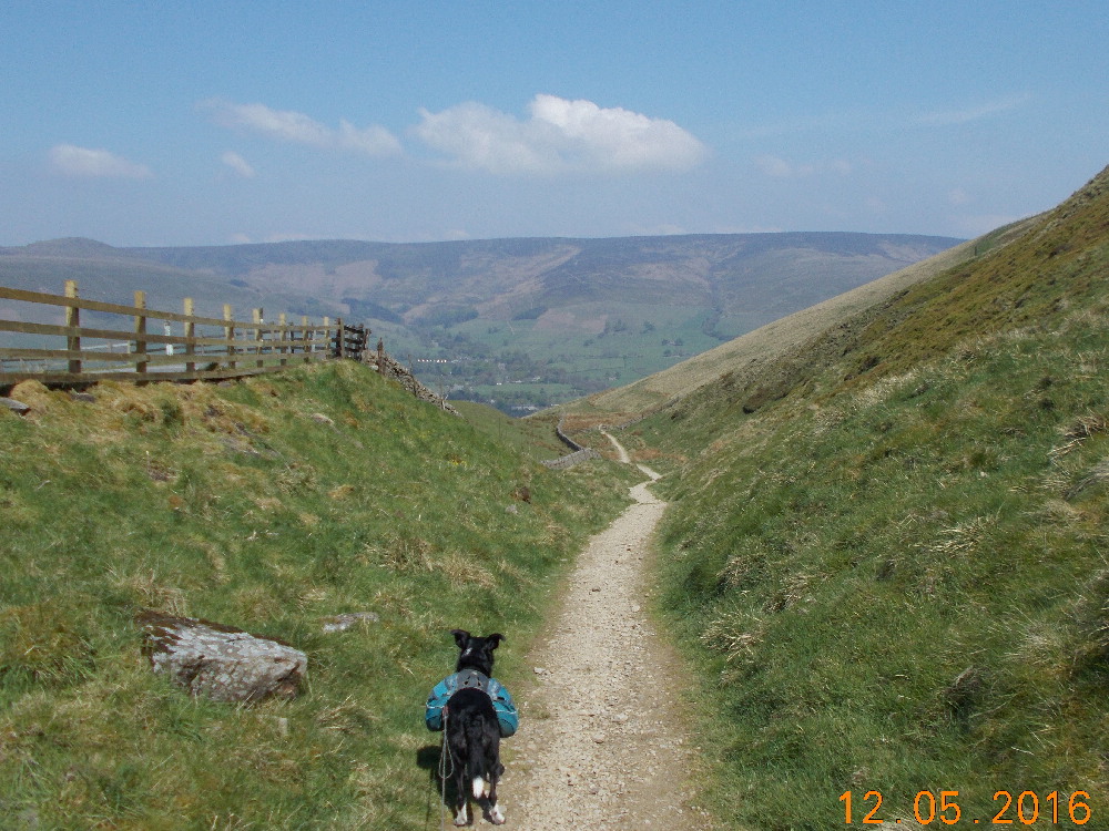
But all was not lost, for I took the advice of a chap who’s back yard I ended up in  and explored the relatively newly created and-not-on-my map Pennine bridleway which, complete with a new surface and signs and gates, follows the railway line from Garsdale to the Moorcock Inn and then up the hill to join Lady Anne’s Highway aka “The Old Road”. So I changed the route and thus, avoided any brutal struggles with difficult tussocks and bog.

ramshaw reccy 005

The second reccy was in the company of Dave and Ruth, erstwhile DCC walks stewards who came along to test Dave’s ankle following an injury. Me and Dawn did the same walk last year but the actual DCC event was abandoned halfway around due to the monsoon season which hit as I was scoffing an egg and tomato butty at lunchtime. The route is OK, no real issues and so it will be attempted once more in it’s entirity next Wednesday.

I have some others to do later – notably a walk from Tan Hill to Keld and back via the cream teas emporium and sheepfarm at Ravenseat.

ramshaw reccy 003

But after September, I’m having a rest from the guided walks till at least March. Back in the winter, I had a slip on some wet grass and had to visit A&E where I had my thigh fondled by  a very nice nurse (there’s always an upside to everything, I suppose). I was advised that I hadn’t broken anything and to hop it whilst taking Ibruprofen and this is what I did, and everything seemed fine for a while.

ramshaw reccy 008

Then, apparently at random this huge and wobbly lump appeared on my thigh and I’m currently waiting for it to be scanned. The doc (he’s probably only twelve years old by the way) says it’s probably a fatty lump and will have to come out. It is spoiling the silhouette of my otherwise rather beautiful leg and it’s not the same shape as the other one which remains quite lovely specially in fishnet stockings….

mallerstang reccy 015

This  surgical interference is likely to leave a substantial hole where a substantial hole has no business and, I suspect, there’ll be recovery time. The problem is that I’m supposed to plan walks between October and next March, and I have no idea when this lumpectomy is likely to be. So I can’t plan guided walks, see?

In the meantime, I can and will keep walking. The doc says that if I don’t stay active he’ll tell his Dad and his Dad is a boxer-policeman and will bash my Dad. And I can go swimming, do yoga, play the piano and watch Wales play footy on the telly and any kind of exciting and energetic activity providing it doesn’t involve more than 28 units of alcohol per day, sorry, week and I cut out the Lancashire cheese unless it’s grated.  But any ambitions concerning my playing for Burnley as a centre-forward in a shirt with “Ray Pointer” written on the back really ought to be reconsidered. In fact, this is Right Out.

On the upside I’m looking forward to even more episodes of leg-fondling by lovely nurses (this is not the main reason I joined the NHS by the way back in 1970 but it did turn out to be a happy side-effect.) and providing the surgeon has been sobered-up before the theatre session, I’ll be OK. Probably.

I would publish a pic of the lump, but you’d be sick.

Thursday, 23 June 2016

Howgills Wild Snoozathon

solstice camp 009

I like to have a camp-out at solstice time and it would be nice to actually witness the sunrise. In the past the solstice sunrise has been missed by a series of unfortunate incidents – too much whisky and a shivery wait on Bolt’s Law resulting in a retreat into a sleeping bag and then waking up at 09:00…. several soltsices involving gales and tipping rain… drifting off into a reverie under a basha on Middlehope Moor and so on and so on.

solstice camp 002

And ,me and Dawn and LTD had recently had a series of camps where we had to get up, feed, pack up and move on for another day’s slog on the beer-trek and the prospect of spending a day camping in one place was attractive as an anti-dote to the hard work…

solstice camp 004

So we decided on a solstice camp for a couple of days in a place where, if an unhidden sunrise were to occur, we would be bound to see it. And then we could spend a day doing nowt at all. Green Bell in the Howgill Fells was chosen.

solstice camp 005

solstice camp 006

We didn’t quite get to the top. I meantersay, it’s two miles from the outer suburbs of Ravenstonedale where we’d abandoned the knipemobile AND it’s all uphill AND the wind was blowing a bit of a hoolie AND we found a sheltered shelf with an old sheepfold and an equally old sheep plus a little spring of water pure and cold and straight out of the ground. It was only just a little tilted but it was there we spent the next two nights.

solstice camp 012

And it had a view to the North and East – mainly the North Pennine scarp from Stainmore along to Cross Fell and North-West to the edge of the Caldbeck Fells. Inspecting the view would take up a fair amount of the time available.

Sunrise #1 was spoiled by the sudden appearance of a huge black cloud and some drizzle, so I snuggled back to sleep.

Sunrise #2 was just a hint of orange, so I snuggled….

solstice camp 010

Lucky spent the bulk of morning#1 asleep under my down gilet and most of the rest of the day stretched out in the sun. We did have a little walk up the 50 metre climb to Green Bell summit and along to Randygill Top and back – joined by Dawn. It was a brief interval of brutality, though, on a day mainly taken up by reading, drinking tea and drifting off into dreamy-sleepy-snoozy land where the only difficulties and frustrations involved the perenial struggle with Kylie’s ever-difficult bra strap and that strange dream about living in a house with loads of water pouring in through holes in the roof.

solstice camp 013

I spent a large part of the afternoon watching a stonechat feed three  fledglings. Fascinating stuff watching the little-uns dip and “chat” and scutter around after Mum who kept up a supply of bugs (I assume) all afternoon. It seems they have their favourite rocks and stones to perch on. Its a long long day in midsummer for a little bird.

solstice camp 014

Morning #2 was equally action-packed and we eventually dragged ourselves away late morning back to Ravenstonedale for a chat with a farmer clipping his ewes and the quick bagging of Little Asby Scar, an easy stroll from the road to a delightful limestone pavement with a huge view of everything.

I reckon we did nine miles altogether. Far too much. Far, far too much.

solstice camp 019

Tuesday, 14 June 2016

Fox's Pulpit Wet Day Alternative

Kirkbank, Bro and LTD
 
We (Me, LTD and The Bro) were supposed to be having a little trundle around Coniston Old Man and Wetherlam and, in the process, bagging a couple of very very obscure Synge Tops and a wee Tump called The Bell. But the Met Office/BBC weather forecast consistently produced dire warnings about torrential showers and thundery thunderstorms with localised flooding (important, this...) over the very fells wot we were intending to do.
 
So we didn't. Instead, we headed for a triumvirate of diminutives not towering over Sedbergh at all, but lurking quite close by (to Sedbergh).
Baby cows (no trouble from these babes)
 
And, parking neatly in a very small layby on the A whatever-it-is,  we headed off through a sheep-pasture for the first top - one brackeny and tussocky Kirkbank, a hill, I suspect, where almost nobody goes unless they're after obscure Cumbrian Tumps. This is a bit of a shame, really, because it has a fine view of the Howgill Fells. The day was warm and fairly bright and it seemed unlikely that the Met Office's dire prognostications would actually happen. And since we'd abandoned the higher and more prettier and altogether more betterer fells of Coniston for these nests of horseflies and deep grass, it seemed a shame. I came to hope that it would rain. Heavily. But not yet.
Howgill Fells
 

We headed off in completely the wrong direction for our next target - the 305 metre Tump of Knotts. This was deliberate and was really just to make the walk a bit longer.Instead, we wandered off South-West to Greenholme and then on a pleasant path North to Shakla Bank where there were flowering haymeadows which was all very nice.
 
More haymeadows and cow pastures, complete with the bovine version of  teenagers, we came to a path traversing the hillside parallel to the Howgill Fells. This produced some surprisingly cracking views of the Howgills (see the video below!) (This was take 2, take 1 being spoilt by some off-screen swearing because I couldn't find how to stop the recording, a short sequence of some boots and paws and a plastic sandwich bag obscuring the screen. You don't really want to see Take 1.
Knotts
 
 
And so, up to the many tops of Knotts and a long  and ultimately successful search for Fox's Pulpit. It seems that this very hillside was , on 13 June 1652, the place where George Fox preached for three hours to 1000 people, an incident which lead directly to the founding of the Society Of Friends (aka Quakers). There's also a small and simple burial ground close by containing a few very old graves and, probably, just the sort of place that a Pieman might rest his ashes should the Quakers ever allow such a thing to happen to a soul-doomed pagan. Was it a coincidence that the date was also 13 June... albeit 364 years later?  Probably.
Fox's Pulpit plaque
 
 
Onwards and upwards and, by missing a path and leaping gracefully over a drystone wall, we achieved top number three - Firbank Fell 324 metres, with it's commanding view of the M6 motorway. It was with some delight that we noticed that , to the South, Kirkby Lonsdale seemed to be getting a bit of a pasting from a localised storm but that the dark clouds seemed to be closing in on us from the South and from the North. A few spots of light rain made us walk a bit faster, Southwards, over the rough moor back towards our little layby.
Gloom moves in...
 
 
In the last few hundred yards, the skies opened and we finally got wet. It was too short a distance to put the waterproofs on. So we got wet.
 
Yay!
 
There's a map. Its quite a nice walk, actually, through meadows and little woods and over moors and stuff and with really nice views all around. And cheap, too, at just 7 of the Queen's miles.


Monday, 6 June 2016

England's Highest Pub Crawl - A bunch of pictures

Camp near Laddow rocks

This may be my final pontification on the subject of England’s highest pub crawl – unless and until we fill in the gap between Todmorden and Skipton.

I have lots of photies and it would be a shame not to show some of them to give peeps some idea of the walk and, hopefully, maybe an idea will insinuate itself into the occasional braincell that this jaunt is a jaunt worth jaunting.

I meantersay, there’s beer involved. Lots of beer. Potentially – much of it really nice..  And lots of walking too..

Just sayin’

If anybody wants route details with extra options for variations (as if you couldn't make these up yourselves!) you know where I am - email address in my profile...

Anyway, I hope you enjoy the pictures. Click on a picture to make it bigger
Flash! Gordon's alive!!


Damp start

Deepdale (Midshires Way)

Bradwell Moor

Down to Edale

Grindsbrook

Camp Snake Pass

Bleaklow

 
Laddow Rocks

Summit of Black Hill

Haigh Gutter camp


Blackstone Edge

Camp near Stoodley Pike

..and squeeeeze...

Dales High Way Malham Moor

Gordale Scar

Malham Moor

Littondale - Knipe Scar

Descending to Kettlewell

Above Cray - Wharfedale

A wet do on Shunner Fell

Tan Hill Inn (Yay!!)

Coast to Coast path

Shooting box on the CtoC

Railway path to Smardale

Smardale Bridge camp

Snoozy snoozy sleepy time

Swindale

Camp at Mosedale Cottage

Haweswater from Harter Fell

High Street from Mardale Ill Bell

Ill Bell ridge

Memorial on Stony Cove Pike

Kirkstone Pass Inn from above!

Discreet camp ..somewhere..... must tidy up...