statcounter

Thursday, 3 July 2014

High Cup Nick – Co Durham Guided Walk

high cup nick nick

It seems that everybody (and his dog… sniff…) wants to go to High Cup Nick at the moment. This was my guided walk and, apparently , there’s another two guided walks to the same place from Cow Green within the next week or two or three..

Or four – look, I’m not sure when the other walks are taking place.

This one was yesterday and 37 (possibly 38) people turned up including stewards Ralph, Compulsory Dave and Ruth.

merr to the met office

tees below cauldron snout

It was supposed to be the hottest day of the year but, in point of fact it was cloudy, windy and a bit on the cool side. So much for the met office and the Beeb who seem to believe them. Another hottest day of the year is supposed to be happening today. Not at Pietowers, it isn’t. In fact, I believe that this phenomena is only taking place in the bottom right sixteenth, or, possibly, generously, eighth portion of the British Isles.

i became aware that I was being followed...

I did the reccy all on my own with nobody with me last Sunday in tolerably warm conditions.

coffee time

...possibly off -route

definately off-route

I have to report that on both walks nothing at all happened and nobody was injured, hurt, disrespected or lost. A cheese sandwich did receive fatal damage as did a small family of red seedless grapes and some jelly babies.

new estate road

For those intent on walking the Pennine Way between Langdon Beck and Dufton, you should note that the Birkdale estate is currently making a real pig’s ear of constructing estate roads between Birkdale farm and Maize Beck and that the PW flagstones are buried underneath it.  The stones of this road are loosely put together and will rumble under the boots of the Pennine Wayfarer and there is some serious danger of coming a cropper on it unless extreme care is taken. You may be well advised to get the web address of a “No Win No Fee” claims company before you embark from Birkdale farm.

maize beck gorge DSCN1703

DSCN1704

We went up the PW, across to the rather lovely limestone gorge on the PW flood route and back the way we came. This little gorge has a selection of fine camping spots, interesting rock formations, small caves and pools and the walls are decorated with wild flowers.

oh the summer time is comin and the leaves are sweetly bloomin

The flower-of-the-day, though was the carpets of scented wild thyme which are everywhere on the limestone bits of the moor.

Here’s a map.

high cup nick

It’s 14 miles.

Some of today’s pics were donated by walkers on the guided walk – notably Graeme and Jo. Ta Graeme and Jo.

Print

Click the Mind logo to donate.

Monday, 30 June 2014

Galloway Bagging Day – 2 Marilyns, a Hump and a Tump

mountain warehouse pack

This was a bit of a filler in between backpacking trips and, dogless, I had to drive all the way to Galloway myself, which was a bugger. But Galloway is nice and soft and green and a bit empty when compared with the hustle and bustle of the North Pennines and the crowds in the Howgills, so it was time for some quiet and contemplative contour-bashing, just me and the dog’s lead.

I started off with the Keir Hills – a little ridge somewhere up a small road out of Dumfries. This ridge is well defended by wobbly walls, barbed wire and electric fences, plus some really really ancient hurdles clearly put together before nails were invented and each one dangerously dangerous in a specially delicate and wobbly kind of way..

wauk hill summit

But the ridge held two ticks – thus the 327 metre Tump, The Mull was bagged, followed by a lovely but barricaded ridge to the 357 metre Marilyn Wauk Hill.  This is a nice top with lovely views of the Rhinns of Kells, Cairnsmore of Carsphairn, The Lowther Hills and the Northern Lake District fells, specially Skiddaw, rising out of the waters of the Solway,  plus, as a bonus, some sixty or seventy wind turbines, some of which were actually turning. Unusual.  Nice.

Mountain Warehouse have recently sent me some rucksacks, one of which I’ve sold – proceeds to Mind -  and the other, I took on this trip. I promised to do a review and I’ll do this after I’ve used it for a bit. It seems OK, though and above is a portrait of the pack at the top of Wauk Hill.

bogrie hill

And so, having studied the view for a bit, I returned whence I came over the lovely but barricaded ridge back to the knipemobile, badly parked near the summit of the white road on the bealach or pass between The Mull and Fleucharg Hill.

clearance cairns

Next -  some distance away, I parked badly again on a side road out of Glenesslin for the bagging of the 432 metre Marilyn Bogrie Hill. This was fairly easily done being just over a mile and about 700 feet of up from the parking spot to the top. The hillside lower down the fell has derelict pastures and each pasture seems to have at least one, sometimes two or three ancient clearance cairns. Some of these are quite well built and are more than just piles of stones. This must have taken some significant effort over a long period for what is now just a sheep pasture. Just sayin’, like…

castramon hill from bogrie

Not satisfied with this meagre ticking bag, I decided to climb the 358 metre Hump Castramon Hill – a mile and 450 feet of up to the immediate South. Both these hills provide extensive and similar views to Wauk Hill and Castramon has a rather lovely steep and rocky northern face to it for a bit of extra fun. I had intended to climb a third Marilyn – Killyleoch Hill but having run out of energy, time and mars bars, I thought it best to go home. I’ll come back and do another three later on.

view west from castramon

Total bag for the day – 2 Marilyns, 1 Hump, 1 Tump, 8 miles 2000 feet of up. 1 cheese and tomato barm cake, 1 banana, 1 mars bar, 1 apple and blackberry turnover, 1 pint filter coffee, thirty quids worth of four star.

Print

Click on logo to donate!!!

Wednesday, 25 June 2014

Weardale Skyline Day 3 and a Bit (The Black Bull Ending)

ruins of park wall farm

I fell asleep straight after dinner and woke up at about midnight. It wasn’t very dark and I decided that after all I would be able to watch the sun come up and started tucking into my generous supply of cheap scotch.

During the next couple of hours I was visited by some grumpy sheep who considered that I was camping on their overnight snoozing spot, a jacksnipe going “whirrrrrrrr” and what appeared to be a rat sneaking by hoping not to be noticed.

either shorngate cross currick or a stone spaceship

At about 3:00 am there was some kind of time/space continuum accident during which a timewarp collided with The Earth, and concentrating it’s magnetic forces in an invisible Cone of Power on Middlehope Moor, just, in fact, where I was sitting enjoying the last dregs of my whisky,  I was suddenly transported forwards in time by about three hours. It was now full daylight. There was hot sunshine and a text message from Brian about what a bonny sunrise it had been. Luckily I had been returned to exactly the same spot, so I wouldn’t have to retrace my steps to finish the walk properly. This was a relief, I can tell you.

Somewhat dazed by this experience, I breakfasted on porridge and prunes (a backpacking favourite) and marched off to bag the summit of Middlehope Moor, just a few hundred metres North.

retrospect to killhope law

I continued Northwards across some more really rough stuff (gwan, ask me how rough it was…) to cross the Allenheads road at Shorngate Cross Currick – apparently a popular parking spot for CtoC cycling support vans. (Support vans hah! Wimps!)

I continues even more Northwards for a bit and then back towards Denmark over the excessively rough and bobbly Redburn Edge/Dry Rigg which has a trig point which isnlt marked on my map for some reason.
bolts law

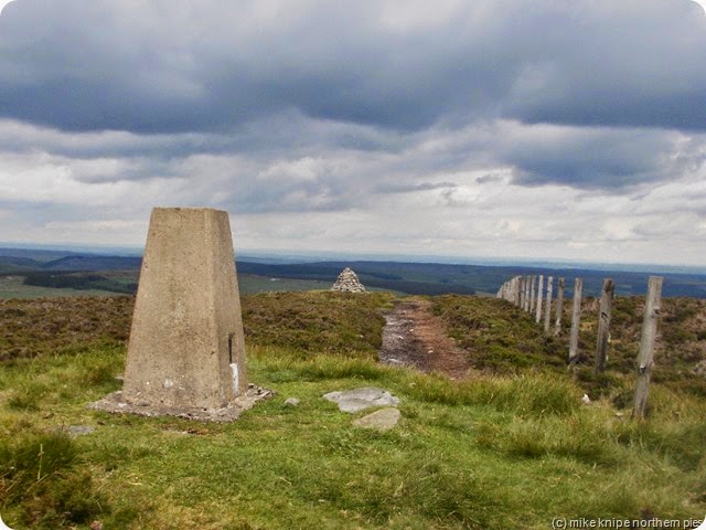
Yet more tussocks and damp were crossed, finally to the road summit at Packlett’s Gate where all became sweetness and light again and, apart from a very short section on the descent from Bolt’s Law, it was now all on tracks or good paths.

old train line

I followed the track or good path to the top of Bolt’s Law – probably the finest viewpoint for a sunrise in Co Durham, through the heather on the other side to join the CtoC route which runs on the  old Rookhope – Sunderland railway line. This is not the skyline, really, but does allow the ever-so-marginally fragged rambler to make quick and easy, if a bit dull, progress to the cafe at Park Head where a hot beef butty and a cuppa can be enjoyed with the cyclists.
wanky!

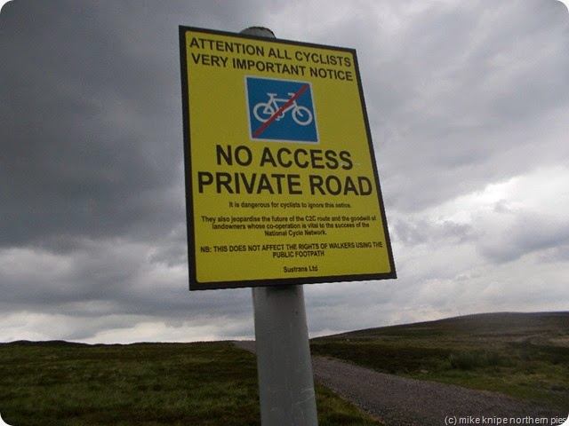
The views are good but the only excitement on this part of the walk is the wanky signs which start with “Attention All Cyclists. Very Important Notice” which , basically say that people on bikes aren’t allowed on certain bits of road cos it’s really dangerous and if they go there, all sustrans routes will be banned and they’ll get the blame. Its not dangerous for walkers, though.
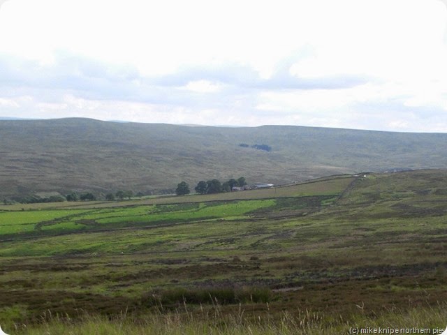
view to crow coal hill

park head cafe

Hennyway, having enjoyed my cuppa and butty, I headed down the Waskerly Way – another railway line route which heads for Stanhope, but I turned off on the road to the wireless mast on the top of Collier Law. Now the wireless mast has disappeared, just in case you’re using it for navigation. Its not there anymore. There is a modern mast some distance down the track, but its not the same one. The road’s still there which presumably means that anyone with mobility issues (i.e. problems) could drive up to the site of the mast to watch the sun come up or, indeed, have an illicit and discreet liaison with a care worker’s friend with little chance of discovery. Just a tip there for anybody searching for a suitable location for such a situation.

bijoux hut

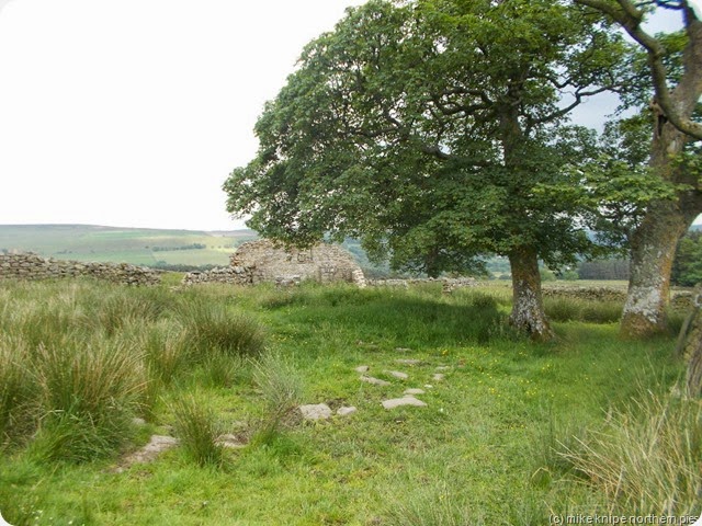
The next landmark is a small  but bijoux shooting hut some two and a bit kilometres in the approximate direction of Belgium. The rough heatheriness is relieved somewhat by the fact that the  heather has been burned at various times into small squares and by moving in patterns not dissimilar to a rook (in chess, not a small crow), an easy passage can be worked out to arrive, more or less in one piece at the lovely little stone house.

carr stones

Carr Stones and Park Wall Edge follow and excitement grows as the outer suburbs of Wolsingham come into view.

wolsingham meadows

All that remains are the green and pleasant meadows and pastures leading into Wolsingham and the waiting Mrs Pieman – usefully waiting, in fact, outside the Black Bull where rehydration took place. (Rehydration is important to ward off any further time/space continuum incidents. This is a well-know medical fact and I would go so far as to post a notice starting with “Attention All Ramblers. Very Important Notice”)

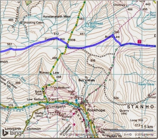
That’s the end of that walk, then. For anybody interested in giving it a go (are you mad or something?) , the route here is 50 miles and 4800 feet of uphill (which isn’t a lot for 50 miles). I thought it was quite hard work.

Maps below.
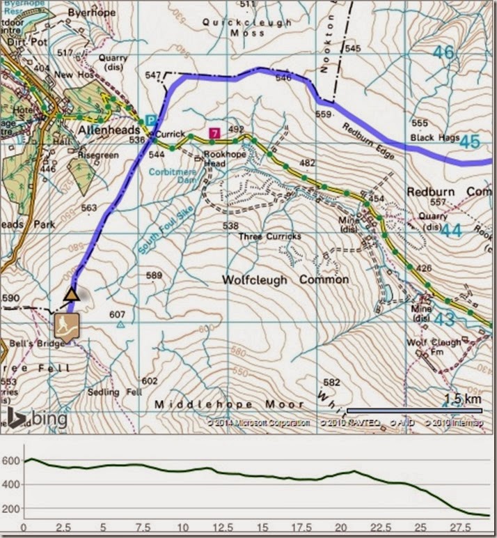
weardale skyline pt 7

weardale skyline pt 8

weardale skyline pt 9

weardale skyline pt 10

weardale skyline pt 11

Print

Click logo to see rude pictures!  (Or just to donate)

Tuesday, 24 June 2014

Weardale Skyline Day2 and a bit

dead stones summit

The clear, starlit and drippy night ended in a grey and cloudy dawn.

I found the boundary fence which I’d been following since yesterday and followed it again. Despite the protestations of the 1:25k map, it does go all the way to Killhope Cross even though it tends to do straight lines instead of following the Cumbria/Durham border exactly. This is where a GPS loaded with 1:50k maps might seem to be a bit inaccurate.

open spaces....

This ridge would be a nightmare for anybody with a phobia concerning open spaces, being alone , having no phone signal or choking to death on a jelly baby whilst trying to ring for the air ambulance. Eat your jelly babies carefully is the best advice I can give.

redgleam fossil

burnhope seat

I plodded over Redgleam and the Durham summit of Burnhope Seat (the highest point is an enclosure away in Cumbria – and along the flat and straight boundary walk to Redgleam where the threat of drizzle and the clouding-up of higher fells such as Cross Fell, suddenly gave way to some clear arctic air with blue skies, fluffy clouds and huge views. Redgleam has a small collection of unusual fossils imprinted into the sandstone. I might collect one at some point.

endless space. well, not actually endless..

I investigated the howff on Dead Stones. I’d not been here since I planted some fuel for a winter solstice overnight trip some two or three years ago – a trip foiled by a blizzard which covered the hill in deep and soft snow of the kind where no progress can be made without snowshoes or skis at least.

deadstones howff the roof (talk quietly!)

I was surprised to find my bag of firewood still there, although the firelogs had gone. And the roof was still just about holding up – I thought the heavy snows might have finally brought it down. The main beam, though is shredded and looks alarmingly shaky. This is not the place to have a noisy argument or to set off loud bangs, or to poke the ceiling with a big stick. It needs mending – basically rebuilding. The rest of the hut seems solid enough. I’m not sure who might do this work or whether the estate would agree anyway.

cross fell in clear air


Anyway – onwards to a shower of text and answer phone messages asking for my whereabouts. I did manage to arrange to meet Brian at Killhope Cross briefly and he took me to Nenthead for some coffee and welcome relief from the tussocky plodding. This interval was soon ended, though and I was returned to Killhope Cross to resume the struggle with Killhope Law.

killhope cross - me arriving

DSCN1653 

Now the bit of land between Killhope Cross and Killhope Law summit has some magnificent peat hags – a real jumble of lumps, bumps and ponds intended to weaken by exhaustion the over-loaded rambler well before he comes across the colony of hysterical black headed gulls screaming and wheeling above their nests.

That over with, I followed a thin path which had developed from somewhere and which lead to the currick on the Eastern end of the hill. This is a fine place for the scoffing of oatcakes,cheese and jelly babies and has a cracking view of Weardale.killhope law currick

More rough stuff follows over Stangend Rigg. The key to navigating the summit and boundary – in this case the Northumberland/Durham border is a shallow ditch which starts on the West side of Killhope Law and runs as far as Stangend Rigg – possibly further. Following this shallow ditch will ensure that the overloaded and exhausted rambler (see above) won’t have any navigational difficulties even in the thickest of weather. In fact , if he is with friends, or even rivals, they will be impressed by his ability to navigate such an apparently blank piece of landscape so easily. Its a trick, really, but there’s no other reason to have this two or three-metre wide square ditch and it’s hardly noticeable in some places being very very old. Quite like me in many ways.

middlehope moor bivi 

I crossed the road to Allenheads and did the final few metres up the flank of Middlehope Moor to where the bridleway from Cowshill meets the County boundary. From here, a vague path leads off South-West and comes eventually to a shelter – maybe half a sheepfold. Here I put up the basha in a formation which protected me from the strong wind but which gave me a view to the East for the sunrise. I collected water from an algae-ridden trickle a bit further East. This usually has a substantial stream, but now was just a dry and rocky slot, complete with a trapped lamb, which I rescued cos I iz an angel, innit?

It spent a pleasant evening completing the consumption of my whisky supply and brewing up/scoffing/snoozing etc – to such an extent that I missed the dawn again – and the call from Brian who was watching it from Killhope Cross.

solstice sunrise

Well dhuhhhh…. there’s always the Christmas one I suppose….

I was now up to 32 miles and 4000 feet of ascent. Alert readers will note that today’s ascent was only 1000 feet. So, its pretty gentle.

Maps below.

weardale skyline pt 4

weardale skyline pt 5

weardale skyline part 6

Print

Click The Logo!!!!