statcounter

Monday, 4 November 2013

A Wet Weekend With the Fight Club Hikers

a  small party in the hut

Well worra washout. The plan was to camp at Buttermere on Friday night and walk up to Haystacks for a convivial wild camp up there on Saturday night.

masey gill

On Friday night, we had a few drinks…. and it blew a hoolie all night and chucked it down, so much so that some tents had their own moats by the morning – which was cold, wet and windy and looked to be settled in for the day. So we went to Keswick for Goulash, Pie and Chips and Venison Pie and some light shopping.

peter paddy

Saturday evening was spent in the hut or shelter on the campsite and a little party developed. Masey and TDude cheated at quiztime by getting the questions right. It continued to sporadically chuck it down and/or be quite breezy most of the night. At some hazy point, I had to repeg the akto which was getting smaller inside somehow.

woodstock pepper

On Sunday, on the way home (ish) , I bagged the little HuMP High Park, which is just to the left of Lamplugh and has a nice view of the Solway Firth on one side, with Scottish hills visible, and Ennerdale and environs on the other side.

western fells from high park

On the drive home, I couldn’t help noticing a thin dusting of fresh snow on the very top of Skiddaw and at the high crossing into Weardale, at Killhope Cross, the car thermometer was reading just 3 C.   Brrrr….

solway firth from high park

As far as the walking and camping was concerned, this event was a bit of a washout. As far as boozing is concerned it was a complete success. I enjoyed it anyway. Shame about the storm.

Thursday, 31 October 2013

Skinny Dip Sponsorship Results– The Score on the Door

DSCN0594
This is likely to be the final word on the 2013 North-East Skinny Dip held at Druridge Bay on 22 September 2013.
The virgin giving page is closing today and the amounts of cash raised by Yours Truly and his generous sponsors, and, where the money went, is as follows:
Amount raised on-line, including donations from the UK government exchequer £267.50
Amount raised off-line from family, friends and sponsor form £100
Total £367.50
This was disbursed as follows:
Mind (national mental health charity) £183.75
National Trust £133.75
St Catherine’s Community Centre in Crook £50.00

So, I’m fairly chuffed with that.
Thanks to everybody who stumped up
I’ll probably do it again next year, but its unlikely that I’ll be asking for sponsors – I’ve never been keen on the sponsorship thing for raising charity money, even though it might be effective. But I might do something where people who dish out the spondoolies actually get something material in return. The thinking cap is on…     ouch…..
 

Tuesday, 29 October 2013

Finsthwaite In Final Few Outliers

a top (?) coniston fells behind

Having done with the Hewitts, I now turn my attention to finishing the Wainwright Outlying Fells with a visit to Finsthwaite Beacon. The idea was to finish these in 2013 and, since there’s now only two left, it seems possible that I’ll manage this, although the show ain’t over till the fat lady eats another bun.

ria takes a pic. Bruno stands by for advice

The bro worked out a route and so it was with three Kendallers  (The Bro, Ria and June) and a brown dog (you know who…) that we all went off in convoy to a car park near Finsthwaite. Luckily, June paid the £4.50 fee (Four Pounds Fifty…!   Gasp!  How Much?!) and we set off up a stony path to High Dam. What happened next is a bit of a blur of stony tops, bracken, green paths, forest and walls. I have little idea where we went since I didn’t have a map and I’m not familiar with this area at all.

one of the finsthwaite beacons

Except to say that we visited both the Finsthwaite beacon shown on the hill-bagging site and the other Finsthwaite Beacon shown on the hill-bagging site and a couple of other hills and some tarns – one of which I know was Green Hows Upper Tarn. This is quite pretty and has things to sit on whilst scoffing a chocolate bar, and we got to it by climbing a deer fence, an exploit not specially enjoyed by superdawg since we had to drop him down the other side of it.

somewhere else..dhuhh)

green hows upper tarn

There was lots of bracken and a wall to climb and some very soggy boggy bits to splodge through (I now have two pairs of soaked boots).

Anyway, there’s no map cos I’m not sure where we went, but reports are that we covered six and a half miles (it only seemed like nine and a half) and thirteen hundred feet of uphill.

windermere

The autumn colours and some of the views were up to the usual Lake District standard.

And it was windy and sunny and sometimes rainy.

Only two left, then I’ll have the complete set of Wainwrights – I keep them in a cupboard next to the telly.

sunshine and shower

Sunday, 27 October 2013

The Hills Are Alive With the Sound of …Well, Everything…

orienteerers start here

I went off up Weardale today to reccy a walk that’s on the Durham County Council guided walks programme. Its at Christmas, but I thought I’d better go and take a look.

And I thought it would be a really quiet day on the hills because – some prune had been messing with the clocks again and I kind of assumed that most people would be going for the lie-in and the tea, toast and shag Steve Wright’s Sunday Love Songs AND, the weather was terrible – all windy and rainy and, well, just ‘orrible.

rainbow and ragged sky

So I set off in a brief spell of sunshine, forgetting to pack my waterproof trousers, which I helpfully left in the boot of the knipemobile. And it was soon slashing it down big time in a kind of Very Breezy horizontal kind of way, blustering around and generally trying to remove me hat.

towards the elephant trees

And there seemed to be a bit of a rush-hour going on. Car after car was heading for Doctor’s Gate, a notorious dead-end suitable only for brain-dead off-roadies dying to use their winches and get mud-splattered to heavy metal muzak. Apparently, it was an orienteering event. Harmless fun, in fact. They were all running off in the same direction and making for the same little pond as me – apparently, anyway, their control point was on a quarry spoil heap some meters away.
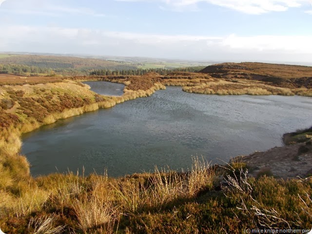
my navigational target

And then as I descended towards the Stanhope Lane, there were horses. I spoke to a lassie with an ATV who seemed to be an organisor , or, perhaps a direction indicator. She told me that it was the Hamsterley Riding Association Annual Halloween Ride, where people pay ten to fifteen quid to have a guided ride around Hamsterley, the proceeds going to a bowel cancer charity in memory of Andrew Moody who died from this disease aged only 23.

And then there were locationally challenged mountain bikers.

And the cattle in the pastures were frisky and very noisy. (apart from the two bulls, who both appeared to have had a sleepless night and seemed to be knackered.)

All day, the wind roared and alternately howled or whined, if there were any wires to whine through and the sun shone, with rainbows, and the rain, when it rained, came sideways and in big lumps.

harthope beck

I teetered across Harthope Beck which was in a Bad Mood and climbed the hill to West Shipley farm where they were doing something obscure with the sheep. Lots of sheep. I spoke to the farmer who gave me a route around the farmyard which only had a little bit of mud and didn’t go through too many sheep, although he didn’t seem too bothered about me walking through the middle of the flock.

weardale railway

Even more and friskier cows followed, or, I should say, some of them followed me. Even the sheep followed me. I entered the woodlands around Black Bank, with some relief – shelter and no cattle. Instead, there was a lass with a huge dog – imagine an evil version of Scooby Doo. She said it was harmless. It looked at me In A Funny Way.

Its not a bad walk – harder than I thought it would be, with some rough moorland, lots of winter mud and a potentially difficult beck crossing. Maybe everything will be frozen.

Didn’t take the dog cos of all the cows. Just as wel, really. It’s eleven miles and 1400 feet of ascent..

And now all my gear is wet. Except for my waterproof overtrousers. (dhuhh)

black bank - doctors gate


Saturday, 26 October 2013

Last of the Lleyn Tops – Gwylyr Gareglefain, Garn Boduan, Carn Fardyn and Mynydd Rhiw. And some paddling.

yr eifl from gareglefain

These last hills are widely separated by green and pleasant countryside which has sufficient wind turbines at the moment (just the one).

We parked in what was optimistically labelled as a picnic area on the OS map, but which, in fact, was a parking place big enough for three or four cars in what seemed to be a very old roadside quarry. It was a very nice quarry, though.

gwylyr gareglefain

We marched off down the road towards Nefyn and turned off up a lane which was occupied by a chap on his mobile and his Jack Russell who seemed friendly enough on the surface. The lane took us towards a rocky knoll which was our target for this morning – one Gwylyr Gareglefain a HuMP of some 261 metres and sporting an easy scramble up it’s Southern slopes. A fine little top, in fact, and, as it was such a nice and warm day, we had a little sitabout for half an hour admiring the view and getting a little tan.

view west from garreglefain

We returned whence we came. This time, the man with the mobile was strimming and was completely engrossed, which was just as well since the Jack Russell and Bruno got themselves into a bum-sniffing competition which ended suddenly when the JR attacked Bruno’s backside quite noisily and grabbed a huge lumpaof flesh and hung on. The skirmish ended suddenly when the little JR seemed to take flight with a little surprised yelp. He flew about two feet in the air and went forward some five or six feet. I’m not sure exactly what happened to him as I was looking the other way [koff…]. No, honestly. Luckily Jones The Grass (Strimmer) didn’t notice and merely remarked in English on what a nice day it was. The JR didn’t seem too upset and trotted along with us happily, but just out of reach of my right boot. As they used to say in the News of the World, I gave my excuses and left.

superdawg leads the way

carn boduan summit

Next was Garn Boduan, which is reached by a little trespass, disturbing a cottage owner having a phone chat in her jimjams, and her little dog who didn’t like Bruno either. bruno, by this time, had decided to get his revenge in first and there was another little noisy but harmless spat. We pushed on into the brambles and trees and, by following the notional path to a better one, we climbed up through the trees to the top. The top was a fine place, rocky and sunny and just the kind of place to sit about for another half an hour. The top has a hillfort with well preserved walls and , just below the summit, the remains of round buildings.

I didn’t want to disturb the lass in her jimjams again, so I took the path down the other side of the hill and used the country lanes to get back to the car.

top of carn fadryn

A short drive followed to the village of Llaniestin, where I parked next to the church and wandered up the lane to Garnfadryn, where I could have parked next to the disused chapel (dhuhh) (pews for sale by the way…)

descending carn fadryn

Carn Fadryn looms above this village in a way which belies it’s short stature  - just 371 metres high but very steep and rocky and covered in huge scree, and appearing more of a mountain than many a much bigger hill. The path to the top is a delight. It winds it’s way easily up through all the scree and bracken and emerges on a heathery top. The summit is an airy perch with the usual sublime Lleyn seaside views on both sides.

pre-paddle

We rejoiced with a visit to the offy in Nefryn and a little paddle at Dinas Dinlle.

mynydd rhiw summit

A few days later, in the face of a really duff weather forecast, we went for lunch near Morfa Neffryn (cracking lamb shank by the way…) and on a bit of a ride around, I managed to quickly bag Mynydd Rhiw, far to the West and my eighth and last Lleyn Marilyn.

Mynydd Rhiw has a wireless mast thingy on the top and is owned by the  National Trust. It also has ancient cairns, a neolithic axe factory (Axes R Us aka Just Axe aka Stone Chopper Inc) and the top is perched on a sharp little knoll. More cracking views. More paddling.

on the beach again

And then we came home and told our Mums all about it.

Next: back to the Pennines!