Odd cloud formation witnessed over the North sea today, just after they’d played “Calling Occupants of Interstellar Craft” by the Carpenters on Radio Sunderland. Was it a message from Outer Space? We are your friends by the way…. Could you lend us ten bob for a bottle of Merlot from the co-op?
Saturday, 30 July 2011
Wednesday, 27 July 2011
Unshackled Navigation – Stuff About It.
Many people will remember UK prime Minister Mrs Margaret (Don’t mess with me, pal) Thatcher. One of her favourite ways of explaining things to people – in that “I seem to be speaking to a mere child” voice she had was to start with “And you know, many people ask me….” and then go on to explain as clearly as possible whatever it was she wanted to say. Nobody had ever asked her , obviously, she just..er… anyway…
Many people ask me if navigating without a map nor a compass nor a GPS ner nowt reminds me, in some tribal-inherited-memory kid of way of my Mesolithic ancestors and how they used to find their way about.
Even though I can accept that there’s probably more than a mere smidgeon of ancestors with Northern roots even older than the Brigantes who considered what a jolly jape it would be to defy the Roman Empire and shout rude words in proto-Welsh from the top of Ingleborough (given that my great granny was Spanish, though…); the answer is “No”.
I went on a little tour of an archaeological site very recently and the question came up as to how Bollihope Moor, in Carboniferous Weardale could have so much flint – a rock which doesn’t occur in the Pennines, but who’s nearest supply is in the chalk of East Yorkshire – a good hundred and twenty or so Celtic miles to the South, given that this was long before the A1 was turned into a dual carriageway and yer Mesolithics probably had to walk too.
Was there a chap with a bag of flints who turned up every third Wednesday of the seventh moon after the winter solstice, saying, gizza piece of hot wild pig and ramson and you can have a couple of flints?
Or was it that the people up on Bollihope Moor had passed through East Yorks on their way home from their annual holidays in Skegness and gathered a load of lumps of flint on their way?
Or did they just swap stuff with other groups? Or maybe it could have been a dowry, or a religious duty to distribute the stuff – or anything – who can know?
The answer seemed to be, evidenced from other nomadic groups currently wandering around other places, and some local evidence, was that these peeps had a kind of circuit. They went to places at certain times of year to take advantage of certain resources available at those places and at those times. So they would know when and where the deer would be in the valley bottoms and they would know where and when the salmon ran upstream. They repeated the same journey, in other words – year after year, generation after generation. So they had mental maps. They remembered where stuff was and if they needed something else, they could ask.
How you find your way down the Pennines is by remembering where stuff is – hills, dales, fences, public bars, spar shops… and remembering what they look like and, roughly, how it all links together.
If you live in the Northern Hemisphere, you know, almost by instinct, that the sun is never ever in the North. It gets close in the mornings and evenings in summer, but it never goes North. If you follow the sun, you will always go Southish.
Forget the rubbish about moss growing on the North side of trees (few trees on the moors) or that cows always point East at night so that they can read their papers without being dazzled by the setting sun – no – its where the sun is.
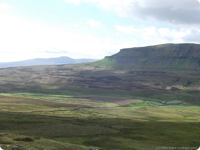
I did get drawn towards things – mainly cairns, stones, the sound of a waterfall and estate roads which would provide easier walking than the soggy Pennine Tussocks. I could hear the artillery at Warcop for the first two days. And from the top of Shunner Fell, I could clearly see Ingleborough, with it’s very distinctive flat, tilted top. Ingleborough dominates the central pennines and can be seen from a wide area. Its no wonder those naughty Brigantes had a fort on it. You can imagine the ramparts being visible from dozens of miles away and the threat or promise of fast moving pony-mounted irregulars appearing suddenly out of the wild Dales ashwoods must have concentrated the minds of Roman patrol commanders. I would have thought.
So, there’s no real mystery to this, in fact it’s very simple – even in places I’d never visited before. From those places, I could recognise the direction and I could recognise nearby features – Shacklesborough, for instance is a small flat-topped gritstone outcrop sitting in a flat tussocky desert. You find your way in the same manner as you negotiate the Huddersfield ring road. You just have to remember what comes up next and what it looks like. Have you just passed the Polytechnic (apols – University) – and which lane should I be in for the turn of to Halifax? This wouldn’t be easy in an area you didn’t already know quite well as anybody who has driven through a strange city might know.
And, just like the navigation of the Huddersfield ring road, you stick to things you can follow. In other words, you handrail things – fences, footpaths, streams – and if you wander away from one of those lines, you keep it in view, or choose another, even at a distance. You don’t leave the ring road.
Simple, really.
Monday, 25 July 2011
Another Kind of Pennine Journey
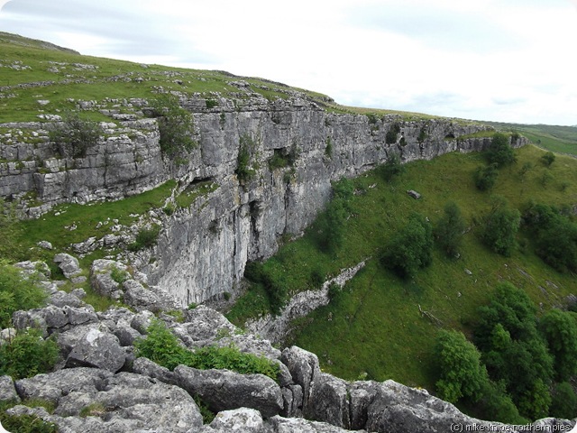
This could well be the very last time that I go banging on about AJ Brown who wrote this ‘ere book, y’see…. anyway, the point is, I tried to walk one of his long distance routes along the Pennines. This was the one that goes from one serious health and safety hazard (High Force) which needs draining and another health and safety hazard (Malham Cove) which needs banking up with a ramp so that nobody can fall off. I mean ter say, its a very big drop.
And the point of the exercise was to see if I could walk between the two without using any navigational equipment at all, apart from the map in my head and a bit of whatever it is that allows you to make reasonable decisions about which direction to go in.
And it was successful in that I left High Force albeit a day late due to duff weather, and arrived five days later at Malham.
Mrs K. dropped me off at High Force Hotel on Wednesday and I managed to find my way over to the South bank of the River Tees using a handy footbridge I knew about (!)
I then got a bit lost. I wandered up the Pennine Way towards Dufton and, after a bit , turned South, but missed the path over Hagworm hill because I had no bloody map, did I?
I did manage to walk Southwards, parallel to the right of way and got to the top of Hagworm Hill (A Hagworm is an adder by the way. or a woman who can turn into an adder, perhaps.) And not long after this I located the Middleton to Brough road and had it in my mind that if I followed this Westwards, I would get to the Durham/Cumbria County boundary and I would be able to follow this for miles and miles and miles…. This worked well. It was a bit rough, but there were boundary stones (strangely numbered ) and a fence.
A long time passed and so did some miles, when I spotted an estate road -- over there…. and the outline of Great Knipe, a hill overlooking the A66. The A66 was a place to go. So I went.
I camped behind a wall over the brow of a hill in a place where I though I would be out of sight of any wandering shepherds or estate workers. One did pass my tent within ten feet, but didn’t see me….
In the meantime, the gunners at Warcop Range had swapped their really big guns/bangs for withering machine gun fire. Note to self: Never try this on the Warcop range.
Thursday, I followed the edge of the scarp to Great Knipe, trespassed a bit in a sheep field and crossed the dual carriageway. The County Boundary would continue from the summit of the road, so I followed the line of the old railway to Tebay and guessed where the boundary was. I got it right and continued boggily Southwards.
And then I got distracted by a bothy. I had to have a look. It was a grand place for lunch. Very plush, in fact. I’m not going to say where it was. Those whom I know are interested in these things may apply for a location.
I returned to the County fence and plodge on through litterless bog, with a view of tan Hill Inn far ahead. Once again I got distracted by a road over there….. or was it over here…. I plodged towards it and followed it to the sanctity and, indeed, sanity of the public bar. The lass serving asked if she could serve me. I said she could. She said she felt loved. I said that so did I.
I followed the Pennine Way to Keld, applied at the farm and put the akto up on the campsite. There were a few midgies.
Friday, I refused the offer of direction from the Pennine Way – at first, at least. I wandered through flowery uncut meadows towards Thwaite and, once on the road, I came across a sign. “Pennine Way Hardraw 8 Miles.” Eight of your Queen’s miles to the George and dragon. Here be cold cider on a warm day. I gave in and followed the Way of the Pennines over Great Shunner fell to the public bar at Hardraw. It Was Worth It.
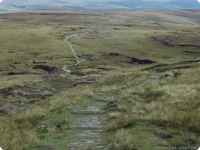
I continued to Hawes, to a phone signal, a Spar shop and a seat outside a pub in the sun. Eventually I left and went to gayle and then, turning away from The Way, I heaved my poor sotted body through the steep contours up to Yorburgh – a green hill far way without a city wall. Or a beck. Luckily, I’d filled up the platypus with three litres of cold beck at the bottom. I camped overlooking Wensleydale on the almost very top of Wether Fell. It was a windy night. No midgies at all.
Saturday, I joined the Roman road to Fleet Moss, wandered down the road to Beckermonds and was joined by three venerable ladies with a map for the climb up and over to Halton Gill. They looked at the map a lot. I didn’t.
A nice, teetering path by Penyghent Gill brought me to the foot of Fountains fell where the Pennine Way meets it coming from the South – see how much distance I’ve saved here…. I couldn’t find any water. A rambling club descended. I asked if that green lump up there was flat on top. One said, helpfully, “It might be…” It was, but covered in thistles. I knew another spot, green and pleasant with a nice, clean beck. It was on the other side of Fountains Fell. crossing it, this late in the day would be a trial. It was. A trial. Oh yes. I did some swearing.
I got a signal and told everybody that needed to know (principally Mrs K) that i was just 12 miles from Malham. As it turned out, my nice campsite by Tennents Gill was more like 6 miles, which I covered the next morning, including a brew and a snooze and feeding the Malham Cove jackdaws on my spare cheese… The Buck Inn gave shelter from the searing sun till Mrs K arrived to bring me home.
I would like to thank the designers of Ingleborough for placing such a dominating and distinctive lump in the landscape, without which this walk could have had problems. Malham is just behind the second hill to the left of Ingleborough, y’see and Ingleborough can be easily picked out from Shunner Fell – or even further North.
What happens when you don’t have a map? I need to let this sink in and will probably post something in a bit.
I measured the route, though – it was 62 miles and 8700 feet of up. I could have made it a bit shorter, but it would have been very very rough.
Tuesday, 19 July 2011
Postponement
Never mind. Here's a song with some shouting.... I'm off to Crook Boozerama for some cheerup fluid...
Sunday, 17 July 2011
Some Things Planned and Some Things Not Very Planned
As it’s been a wet weekend and I’ve done all the rangering that I need to do for now, I could have been doing some writing today.
But I didn’t
What I did do, was that I planned a TGO Challenge route, or at least, most of a TGO challenge route. This will (or, possibly, would, if I don't get a place), from Strathcarron to Struy, to Drumnadrochit, through the Moanyleegach wind factory, down the Avon and finish somewhere around Stonehaven.
One of the sections is a bit long, but if I can buy dehydrated scoff in Aviemore (and I don’t see why not) – it’ll be fine.
That’s the planned bit. There’s more planning to do, obviously, but it’s mainly there – I have the chords and the words…
The unplanned thing I’m planning starts on Wednesday when, somehow (I need to plan this bit) – I’ll get myself to High Force and start walking South. The destination is Malham, or, possibly Skipton. Mrs Pieman has contracted to pick me up and bring me home from wherever I am four days later.
Regular pieblog readers will recognise the project as one which bans the use of maps, compass and GPS and will not follow the Pennine Way, but will be more direct. I’m hoping/expecting that the fact the Ingleborough should be in view most of the time will provide a handy reference. If its foggy, I could have trouble, I suppose, but the route isn’t very high…..
This folly is inspired by AJ Brown’s 1930’s guide “Moorland Tramping West Yorkshire” which I’ve described elsewhere in this pieblog.
Who knows where it will end?
I’m hoping to hit the Tan Hill pub at some point, but if I miss it, it’ll be my own fault.
I’m not planning to run out of food, and have a fair stash left from my Outdoorgrub order. I’ll buy a little more and some in-tent entertainment, but thats it. Thats the plan.
Some things can be overplanned.